Kenya Met Issues Fresh Update as Heavy Rains Continue Nationwide
Share
The Kenya Meteorological Department has issued an update for the Nairobi Metropolitan region, warning that moderate to heavy rainfall and isolated thunderstorms will continue across the area as Heavy Rainfall Advisory No. 02/2026 remains in effect.
According to the update released on March 8, 2026, the advisory will remain valid until March 9 at 19:00 EAT, with residents urged to remain vigilant due to the possibility of flooding in several areas.
Kenya Met noted that although rainfall intensity has slightly reduced compared to the peak period experienced between March 4 and March 7, moderate to heavy showers are still expected across parts of the Nairobi metropolitan region.
In the advisory, the department warned that “the current heavy rainfall of more than 20mm in 24 hours is expected to continue across several parts of the country from March 3rd to March 9, 2026.”
The agency further noted that the rainfall “is likely to intensify and peak between 4th and 7th March 2026, before decreasing in most areas by 8th March 2026.”
Despite the slight reduction in intensity, Kenya Met cautioned that flooding remains possible because soils across the region are already saturated following prolonged rainfall that began toward the end of February.
Also Read: Why Major Nairobi Estates Face Water Shortages Despite Heavy Rains
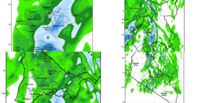
24-Hour Rainfall Outlook for Nairobi
According to the 24-hour rainfall forecast map for Nairobi County (valid 09:00 March 8 to 09:00 March 9), showers are expected to be widespread across the capital, with heavier rainfall likely in eastern and southern sections of the city.
Areas such as southern Embakasi, Makadara, Kamukunji and parts of Kasarani could experience higher rainfall totals compared to other parts of the city.
Kiambu County Rainfall Forecast
Kenya Met has also released a rainfall outlook map for Kiambu County, showing expected precipitation between 09:00 AM on March 8 and 09:00 AM on March 9, 2026.
The forecast covers several sub-counties, including Gatundu North, Gatundu South, Thika Town, Juja, Ruiru, Kiambu, Kiambaa, Githunguri, Lari, Limuru, Kabete and Kikuyu.
The rainfall scale ranges from 2 millimetres (light green) to 100 millimetres (dark red). Most areas on the map are shaded in green tones, indicating light to moderate rainfall expected across the county.
Also Read: Kenya Power Explains Why Some Parts of Nairobi Are Experiencing Blackouts
Kajiado County Rainfall Forecast
A separate rainfall forecast map has also been issued for Kajiado County, covering Kajiado North, Kajiado West, Kajiado Central, Kajiado East and Kajiado South.
The forecast period runs from 09:00 AM on March 8 to 09:00 AM on March 9, with rainfall levels expected to range from 2 mm to 100mm.
Most parts of the county are projected to receive light to moderate rainfall, although distribution varies across the sub-counties.
Flood Risk Remains High
Kenya Met has cautioned that continued rainfall may still cause localized flooding, flash floods and reduced visibility, especially in low-lying areas and locations with poor drainage.
The department warned that “flood waters may appear in places where it has not rained heavily, especially downstream.”
Residents across the Nairobi metropolitan counties, including Nairobi, Kiambu, Kajiado and Machakos, have therefore been urged to remain alert and monitor updates from relevant authorities for sector-specific advisories related to transport, disaster response and public safety.
The agency also advised the public to avoid walking or driving through moving water and to take precautions during thunderstorms.
Follow our WhatsApp channel for instant news updates
Maps showing the forecast in various areas within Nairobi Metropolitan
PHOTO/Kenya Met/X


