
WMO Forecasts Near-100% Chance El Niño Will Persist Through February 2027
Share
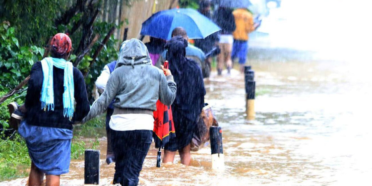
The World Meteorological Organization (WMO) has warned that a strengthening El Niño is likely to continue into early 2027, raising the risk of extreme weather across different parts of the world.
According to the latest WMO El Niño/La Niña Update released on September 3, 2026, forecasts show an exceptionally high likelihood of nearly 100% that El Niño will persist through February 2027.
The climate pattern is expected to strengthen further in the coming months and reach very strong intensity before peaking towards the end of 2026.
WMO said exceptionally warm conditions in the tropical Pacific Ocean are supporting the continued development of the El Niño event.
El Niño Expected to Intensify
Sea surface temperatures in the central and eastern equatorial Pacific are already well above average and continue to rise.
The widely used Niño 3.4 index, which measures sea surface temperature anomalies in the central-eastern equatorial Pacific, averaged 1.5°C above normal between May and July 2026. It then reached 2.0°C above normal in July.
Weekly temperatures rose further between late July and mid-August, reaching approximately 2.2°C to 2.6°C above average.
Conditions below the ocean surface are also unusually warm. In some areas, subsurface ocean temperatures were more than 8°C above average during July and early August.
WMO said the surface and subsurface conditions provide strong evidence that El Niño will continue strengthening.
Risk of Extreme Weather Rises
A very strong El Niño can significantly change rainfall, temperature and atmospheric circulation patterns around the world.
WMO warned that the event could increase the risks of floods, drought and extreme heat in different regions.
For September to November 2026, WMO forecasts show an increased likelihood of above-normal temperatures across almost all land areas.
Rainfall patterns are also expected to reflect the strong El Niño conditions, although the effects will vary from one region to another.
The organization stressed that El Niño’s strength alone does not determine how severe its effects will be in a particular country.
“Very strong El Niño does not mean the same impacts everywhere,” WMO said, noting that its effects depend on location and season.
Other climate drivers, including conditions in the Indian and Atlantic Oceans, can also modify El Niño’s influence.
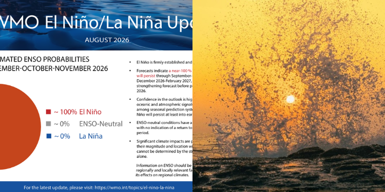
Photo collage of WMO El Niño Update August 2026 and Indian Ocean Dipole. PHOTO/WMO
Indian Ocean Conditions Could Affect Impacts
WMO expects a positive phase of the Indian Ocean Dipole (IOD) to develop, with a September-October-November 2026 seasonal mean value of 0.9°C.
At the same time, the equatorial Atlantic is expected to remain generally warm, with sea surface temperatures in both the North and South Tropical Atlantic above normal.
WMO said these additional climate conditions could reinforce, weaken or alter the typical effects of El Niño in different parts of the world.
The organization has therefore issued a complementary Global Seasonal Climate Update to provide a broader assessment of the expected climate conditions.
Also Read: Kenya Met Reveals October-December Forecast as El Niño Intensifies
Guterres Warns of Extreme Weather Risks
UN Secretary-General António Guterres said the current El Niño event is developing at an exceptional level.
“El Niño is being supersized before our eyes. The science leaves no room for doubt, the planet is in uncharted waters, and those waters are heating up,” Guterres said.
He warned that rising temperatures and sea surface temperatures were putting the world at greater risk of extreme weather.
“The race now is between rising risks and our commitment to take climate action and protect people. We must win that race,” he said.
Also Read: Weatherman Warns of Hot, Dry September as Rainfall Declines
WMO Calls for Stronger Preparedness
Organization Secretary-General Celeste Saulo said communities and economies were already experiencing disruption from droughts and floods as El Niño develops.
“El Niño in Spanish means boy child- but it has the potential to deliver a massive blow to communities and economies across the world,” Saulo said.
She added that the expected strengthening of the event could increase these impacts.
“This exceptional El Niño demands exceptional preparation and response,” Saulo said.
Saulo noted that WMO was working with National Meteorological and Hydrological Services to strengthen preparedness and early-warning efforts.
“WMO is committed to working closely with partners across the United Nations and humanitarian system to provide the climate intelligence and insights needed to support disaster management and climate-sensitive sectors like agriculture, health, energy and water resources,” she said.
“We have no time to lose.”
Early Warnings Remain Critical
El Niño is one of the two phases of the El Niño-Southern Oscillation (ENSO), a major natural climate pattern.
It occurs when ocean surface temperatures in the central and eastern equatorial Pacific become unusually warm. El Niño typically develops every two to seven years and lasts about nine to 12 months.
The phenomenon usually begins developing between March and June and reaches its peak between November and February.
Its effects can extend thousands of kilometres from the tropical Pacific and can influence weather patterns well beyond the period of peak ocean warming.
WMO said reliable forecasts give governments, humanitarian agencies, businesses and communities valuable time to prepare for potential impacts.
National Meteorological and Hydrological Services will continue monitoring the event and issuing locally relevant forecasts and warnings.
WMO also stressed that El Niño is a natural climate phenomenon and is not caused by climate change.
Follow our WhatsApp channel for instant news updates.
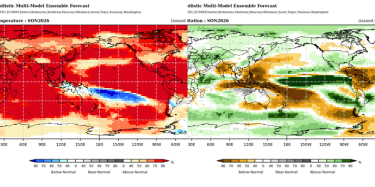
Photo collage of probabilistic forecasts of surface air temperature and rainfall for season September-November 2026
PHOTO/WMO